There are no active watches, warnings or advisories

| White Rock, NM Weather Data | |||
|---|---|---|---|
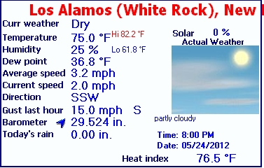
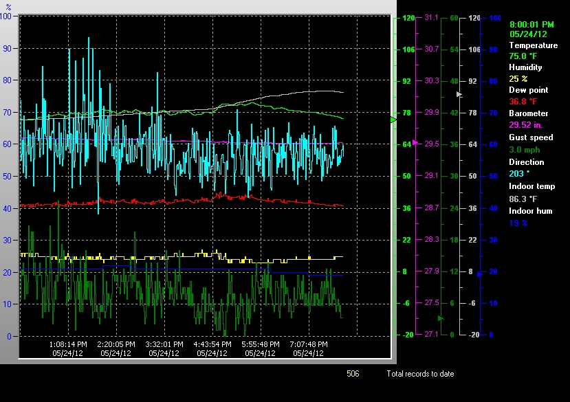
| LAST READING AT TIME: 8:00 PM DATE: May 24 2012 | |||
| Current Weather | Dry | Current Temperature | 75.0°F (23.9°C) (Heat Index 76.5°F ), Apparent temp 72.9°F |
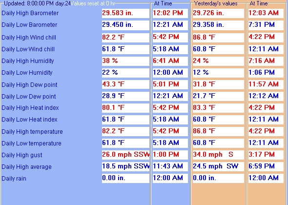
| Maximum Temperature (since midnight) | 82.2°F at: 5:42 PM | Minimum Temperature (since midnight) | 61.8°F at: 5:18 AM |
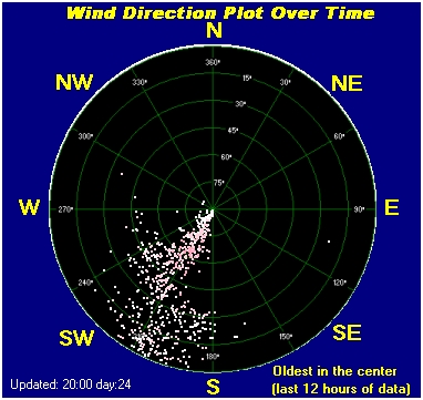
| Average windspeed (ten minute) | 4.4 mph | Wind Direction (ten minute) | SSW (200°) |
| Heat Index | 76.5°F | Maximum Gust (last hour) | 15.0 mph at: 7:25PM |
| Maximum Gust (since midnight) | 26.0 mph at: 1:00 PM | Maximum 1 minute average (since midnight) | 18.5 mph at: 11:43 AM |
| Rainfall (last hour) | 0.00 in. (0.0 mm) | Rainfall (since midnight) | 0.00 in. (0.0 mm) --- |
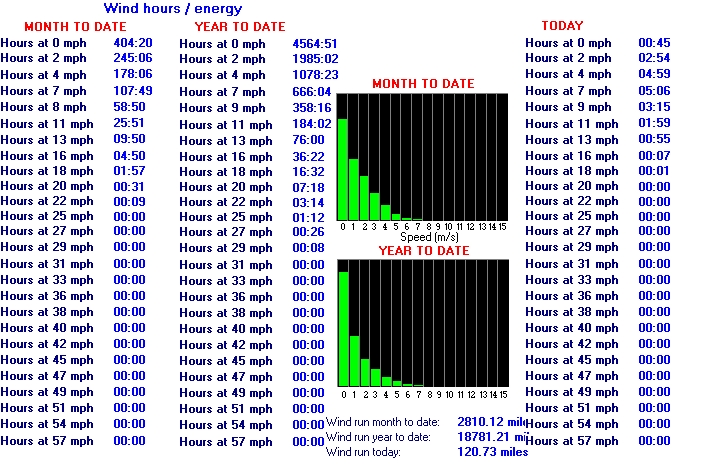
| Rainfall This month | 1.72 in. (43.6 mm) | Rainfall To date this year | 2.26 in. (57.4 mm) |
| Maximum rain per minute (last hour) | 0.00 in/min | Maximum rain per hour (last 6 hours) | 0.00 in/hour |
| Yesterdays rainfall | 0.00 in | DewPoint | 36.8°F (Wet Bulb :56.5°F ) |
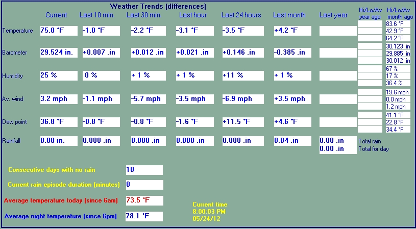
| Humidity | 25 %, Humidex 72.4°F | Barometer corrected to msl | 29.524 in. (999.8 hPa) |
| Pressure change | +0.02 in. (last hour) | Trend (last hour) | RISING SLOWLY |
| Pressure change (last 12 hours) | -0.02 in | Pressure change (last 6 hours) | -0.03 in |


SANTA FE COUNTY MUNICIPAL, NM, United States (KSAF) 35-37N 106-05W 1930M
May 24, 2012 - 07:53 PM EDT / 2012.05.24 2353 UTC
Wind: from the W (260 degrees) at 13 MPH (11 KT) gusting to 21 MPH (18 KT):0
Visibility: 10 mile(s):0
Sky conditions: partly cloudy
Temperature: 81.0 F (27.2 C)
Dew Point: 30.0 F (-1.1 C)
Relative Humidity: 15%
Pressure (altimeter): 29.76 in. Hg (1007 hPa)
Pressure tendency: 0.04 inches (1.4 hPa) lower than three hours ago
ob: KSAF 242353Z 26011G18KT 10SM SCT110 27/M01 A2976 RMK AO2 PK WND 25027/2338 SLP967 T02721011 10278 20239 57014
cycle: 0
Use the RELOAD facility on your browser to retrieve the latest data.